
A WINTERTIME PATTERN TAKES OVER IN THE TROPICS
- Bryan Norcross

- Nov 21, 2020
- 2 min read
Cold fronts backed by strong high-pressure systems and cooler air are pushing through the entire Florida peninsula, while strong upper-level winds are howling across the tropics from the Gulf of Mexico to Africa. These are components of a typical wintertime weather regime in the Northern Hemisphere.
There a still a couple of mechanisms that can occasionally spin up a tropical or quasi-tropical system late in the year, however. In the far southern Caribbean Sea near Colombia and Panama, a small pocket of conditions that could support tropical development hang on longer.
Also, as we saw in June, non-tropical systems can sometimes acquire quasi-tropical characteristics – so called subtropical depressions and storms – if they linger over warm ocean waters long enough. The distinction between non-tropical and subtropical is that subtropical systems get some of their energy from the warm water under them, and not just from the cold fronts or jet-stream dips that formed them.
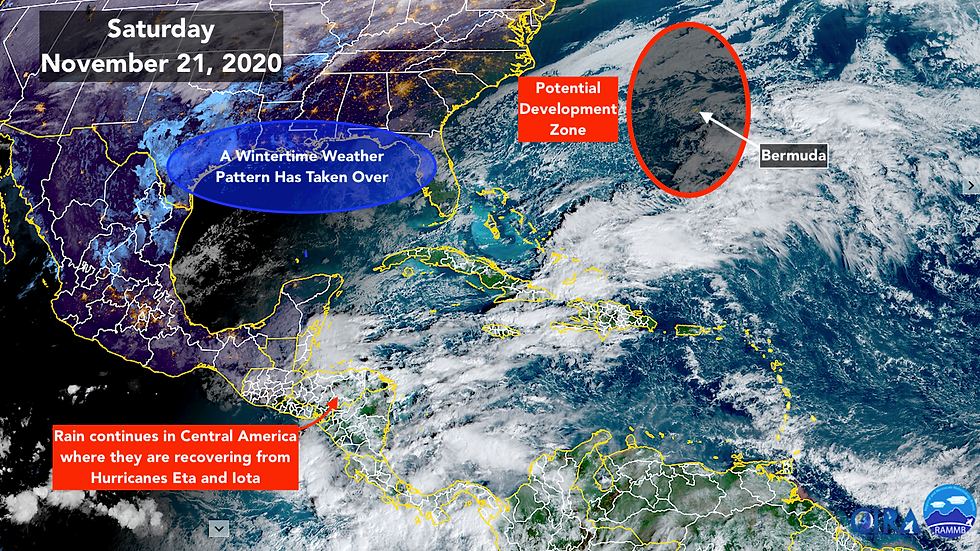
The National Hurricane Center is indicating that there’s a small possibility that one of these subtropical systems will spin up in the next few days in the vicinity of Bermuda. The window of opportunity appears very short, and it would not be a significant threat to Bermuda. It's forecast to quickly move away toward the north-central Atlantic. Bermuda is going to get some rainy weather with the cold front sweeping in whether a subtropical system forms or not.
As with pure tropical storms, these subtropical systems get names from the National Hurricane Center if the winds in the circulation reach 40 mph. The next letter in the Greek alphabet is Kappa, but the odds of it getting used are very low.
Dr. Phil Klotzbach, the guru of hurricane stats from Colorado State University, calculated that Hurricane Season 2020 was a top-2 year in some of the obvious categories: The most named storms; the second-most hurricanes; and tied for the second-most Cat 3+ hurricanes. But, fortunately, it only ranked 13th in the total of number days that hurricanes were active, and 14th in the number of days that Cat 3+ hurricanes were active during the season.
The stats ended up this way because of the outbreak of weak and short-lived systems early in the season, and the fact that tropical storms and hurricanes tended to form closer to the U.S. this year, so they had less distance to travel to get to land, and therefore less time to live.
The bizarrest aspect of the season, of course, was that the hurricanes persistently took three tracks: toward Louisiana, into Central America, and over or near Bermuda. In hurricane seasons of the past, storms have focused on the Northeast U.S., South Florida, and other parts of the coast, so it’s not unprecedented, though thankfully it doesn’t happen often.
Remember that hurricane season isn’t over for people in these highly impacted areas. Recovery from a multi-storm barrage will take years to accomplish.
Here’s hoping that the freak events are over for this hurricane season. Have a Happy Thanksgiving everybody! And stay safe.
Comments