Catastrophic Impacts Possible in the Caribbean from Melissa
- Bryan Norcross

- Oct 23, 2025
- 2 min read
**LIVE Q&A today with me and NHC Director Mike Brennan. We'll be discussing Tropical Storm and eventually Hurricane Melissa LIVE on YouTube, Facebook, TikTok, X, Instagram, and LinkedIn. I hope you'll join us and send in your questions. LIVE at 4 PM ET.

Tropical Storm Melissa
There is a reasonable consensus in the computer forecast models that Tropical Storm Melissa will become Hurricane Melissa over the weekend and turn north next week, crossing Cuba or Haiti before accelerating into the open Atlantic. The questions are when that will happen and how strong Melissa will get while it's crawling across the central Caribbean.

Hostile upper-level winds continue to keep Melissa from strengthening, but they are forecast to let up by tomorrow. As a result, the National Hurricane Center is forecasting Melissa to steadily intensify into a hurricane. As the system drifts over the extremely warm Caribbean waters, with a conducive atmospheric pattern from Sunday to Tuesday, Melissa is forecast to dramatically strengthen into a powerful Category 4 hurricane. A Category 5 can't be ruled out.
The steering currents are forecast to remain very weak for the next several days. Today a modest jet stream dip is tugging Melissa to the north, but the storm is resisting. By the weekend, the steering flow is forecast to nudge Melissa to the west near or south of Jamaica. Next week, another jet stream dip should grab likely-Hurricane Melissa and yank it north or northeast.

The consensus of the various computer forecasts is that that acceleration to the north over Eastern Cuba will occur about Wednesday.
From Sunday until Tuesday, a strong Hurricane Melissa looks likely to be in the vicinity of Jamaica. This could be an extreme situation with relentless torrential rain and strong wind impacting the island. Here is the zone with the threat of hurricane-force winds through Monday night. The peak impacts on Jamaica will come Monday into Tuesday, if the current forecasts are reasonably correct.

In addition, Melissa will grow in size so its outer rain bands will continue to impact the southern coast of Hispaniola—the island containing Haiti and the Dominican Republic. Fringe effects on Puerto Rico could also be significant, and the Caymans will have to watch for developments as well.

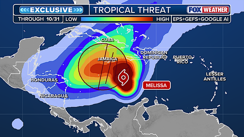
The exclusive FOX Weather Tropical Threat analysis shows the most likely scenario as we have it now. Melissa drifts north then west south of or near Jamaica. Notice that the NHC cone only extends until Tuesday morning, though the colors in the analysis show the odds until Friday. So about Tuesday, the system turns north—again over or near Jamaica—and tracks north, most likely over eastern Cuba. By late Wednesday, if this consensus is right, the system accelerates away.
This has the earmarks of an extreme event for Jamaica, the southern parts of the Dominican Republic and Haiti, eastern Cuba, and possibly the Southeastern Bahamas including the Turks and Caicos. Everybody there should stay well informed and be prepared to take quick action.
There is no indication of a threat to the mainland U.S.

Comments