
Lala Moving Past the Hawaiian Islands Today While the Atlantic Goes Quiet

Hurricane Lala slipped by the southern point of the Big Island of Hawaii yesterday afternoon Hawaii time. Now the storm has weakened some due to its interaction with the huge mountains on Hawaii Island, and a less conducive atmospheric environment.
Tropical Storm Lala is forecast to track parallel to the islands today and move into the open Pacific tonight. Winds gusting near hurricane force are possible on the higher elevations on Maui, Molokai, Oahu, and Kauai. Heavy rain – 6 inches plus or minus with more on Maui – is forecast to fall on the windward slopes of the mountains on all of the smaller Hawaiian Islands.
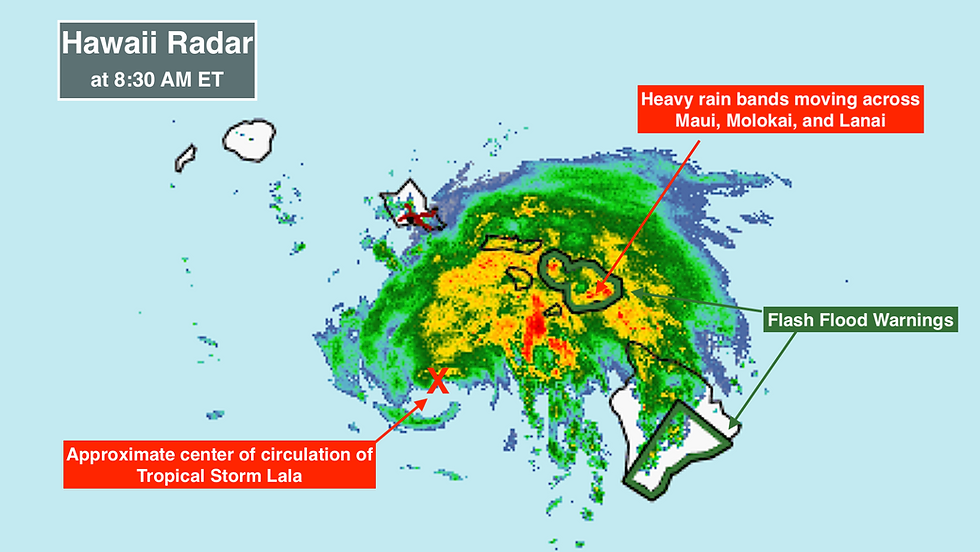
The Big Island is reeling from the hard hit yesterday. Some rain will continue to fall there today, although it won't be reinforced by Lala's strong, tropical-moisture-drenched winds plowing directly into the mountains. The gaps and ridges in between Mauna Loa and Mauna Kea enhance the winds. The winds blowing up the steep slopes enhance the rain. Then all that rain has to drain down the mountain into the Pacific, which can cause big problems as well.
It will take some time to fully assess what has happened on Hawaii Island.
ELSEWHERE IN THE PACIFIC
The National Hurricane Center is identifying two areas to watch. The orange color indicates that there are medium chances at least a tropical depression will form in those potential development zones.

For the one closest to Hawaii, the early forecasts predict that it will probably not affect the island, but that's not 100%. If the system strengthens, there's a slight chance it could turn north. It will be something to watch in a week or so.
The potential development area closer to Mexico looks likely to stay offshore. But moisture from the system could impact Southern California and the Southwest U.S. next week.
IN THE ATLANTIC
The disturbances we were following have fizzled, and the next one in line is not forecast to develop.

Saharan dust and strong upper-level winds driven by El Niño took their toll. So for now, it's all good.
Comments