LAURA ON A SOUTHERN TRACK ACROSS THE CARIBBEAN ISLANDS WHILE MARCO NEAR A HURRICANE IN THE GULF
- Bryan Norcross

- Aug 23, 2020
- 4 min read
Unless something surprising happens, Tropical Storm Laura will pass South Florida well to the south tomorrow. Monday will still be a windy day, but the strongest part of the storm should stay south of the state.
A Tropical Storm Watch is in effect in the Keys for the POSSIBILITY of sustained winds over 40 mph, but mostly the tropical-storm force winds should come in gusts.
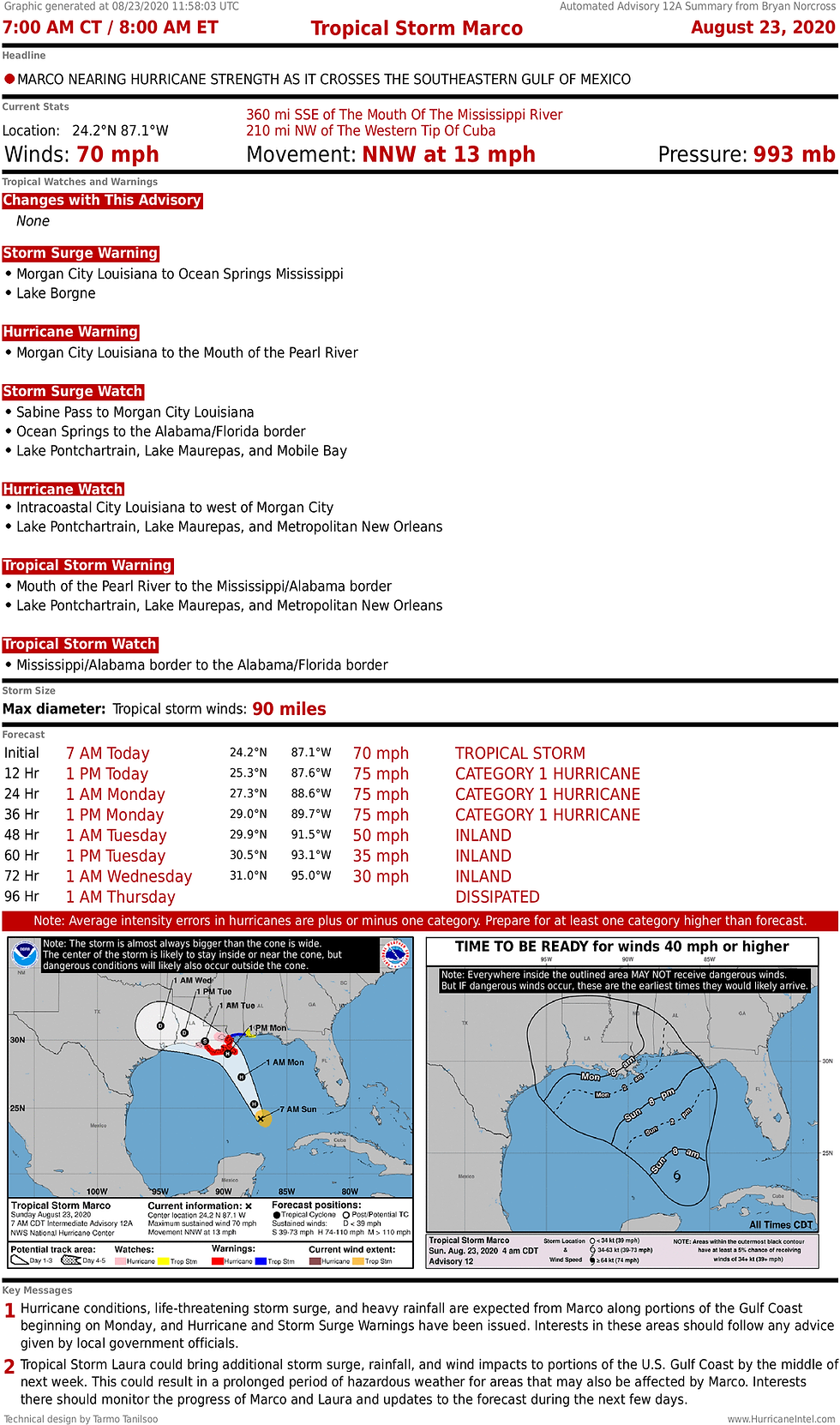
In the Gulf, Tropical Storm Marco is fighting against hostile upper winds as it heads north, but it’s still slowly strengthening. The unsupportive atmospheric environment is forecast to let up enough to allow Marco to become a hurricane before the upper winds pick up again near the time of landfall.
Whether Marco gets to the coast before it weakens significantly is an open question, but just in case, a Hurricane and Storm Surge Warning are in effect for the Louisiana coast south and east of New Orleans. Other alerts are in effect for the rest of the north-central Gulf coast as far east as the Alabama/Florida border.

TROPICAL STORM LAURA
Laura still looks organized on the satellite image, but the circulation has been disrupted by the mountains of the Dominican Republic and Haiti to the point that the center is very hard to discern. We know it was deflected south, however, because it passed over Santo Domingo on the southern coast of the Dominican Republic overnight. The important point is, the storm will be a bit farther south than yesterday's forecast when it reorganizes tomorrow.
Some of the computer forecast models predicted this track, so it’s not a total surprise, but the consensus was a little farther north. In any case, it’s good news for South Florida, and especially the Keys, since the circulation center will track farther away.
The system driving Laura to the west is a strong high-pressure system sprawled across the Atlantic. The air being squeezed between that high and the low pressure of Laura is a band of wind north of the storm’s center. That band of wind will move across South Florida as Laura passes to the south.
The winds may gust near 40 mph in areas exposed to the ocean, high rises, and elevated roadways in Miami-Dade, Broward, and Palm Beach County. The strongest winds will come from the east and southeast. Marine interests should take special note.
In the Keys, the winds may gust a bit higher and affect high-profile vehicles as well. Be sure to follow the instructions of the local authorities, which are designed to keep everybody safe.
By late on Monday, Laura is forecast to be intensifying as it heads into the Gulf. It appears well enough organized to do that fairly quickly. Laura would seem to have plenty of time to become a formidable hurricane as it tracks toward the northern or northwestern Gulf coast.
The eventual landfall point on the northern Gulf coast is unknowable. The level of disruption of Laura’s circulation, the exact track past Cuba, and the speed of movement all come into play, in addition to the typical variables related to predicting the upper-level-wind regime and the exact steering currents.
A band of the coast including the Houston and New Orleans metropolitan areas are in the possible path of potentially significant Hurricane Laura.
Marco will likely have preceded it near the Gulf coast. The lingering effect of that may be elevated water levels at the coast that may not have gone back to normal by the time Laura arrives.
It is exceptionally unusual to have two storms hit land back to back in the same general area, although neither Marco nor Laura is an oddball storm in its own right. Until or unless proven otherwise, we just should think of it as a 2020 coincidence.

TROPICAL STORM MARCO
Marco put on a burst of intensity while it was in the pristine atmosphere of the Caribbean yesterday, but now that the center has moved into the Gulf of Mexico, the atmospheric environment has turned a bit hostile. Over the very warm waters of the Gulf, Marco is still intensifying, but more slowly. Marco is expected to become a hurricane as soon as this morning.
As Marco approaches the Louisiana coast, the destructive upper winds are forecast to increasingly take their toll on the circulation. It is unknown whether it will have made landfall when the dramatic weakening takes place.
Since New Orleans is inland from the coast, the winds should not be as strong there as in the coastal sections. This storm should not challenge the flood-protection levees around New Orleans, but many areas in southeastern Louisiana outside those levees are extremely vulnerable to storm surge, and will be affected by water levels 4 to 6 feet above normal high tide.
Everybody in the storm-threat zone needs to be in preparation mode. The situation is, indeed, complex, but the winds are forecast to start increasing and the water start rising today, so hurricane preparations have to be sped to completion.


Comments