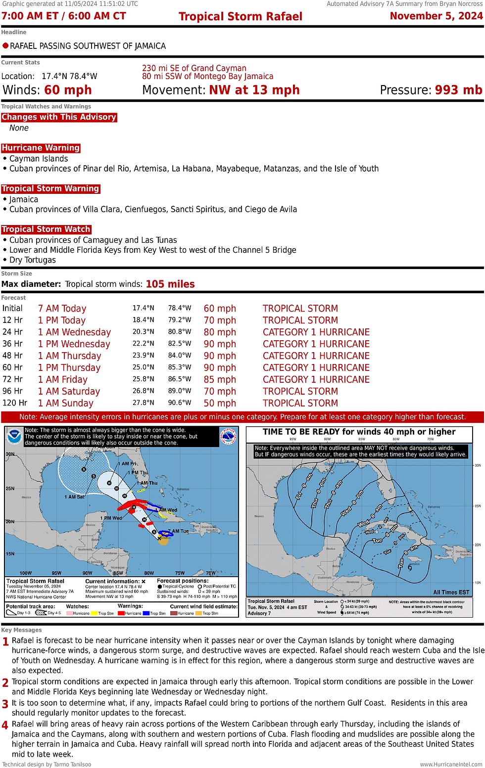
Rafael will reach the Gulf of Mexico tomorrow as a hurricane then the forecast gets fuzzy
- Bryan Norcross

- Nov 5, 2024
- 3 min read
Tropical Storm Rafael is on track and intensifying as predicted. It's passing Jamaica, putting tropical–storm–force winds over the island. The Cayman Islands and western Cuba are next in line. Significant intensification is forecast to continue as it passes over the extremely warm waters of the northwest Caribbean under an atmosphere conducive to strengthening.
Rafael is forecast to reach hurricane strength later today and intensify into a high-end Category One or possibly a Category Two by the time it makes landfall in Cuba overnight.

Once Hurricane Rafael passes into the Gulf on Wednesday, several things will happen at once: it will run into increasingly dry air, upper-level winds will become more hostile, the water below won't transfer as much heat energy to the storm as the super-heated water did in the Caribbean, and the steering currents will collapse so Rafael's direction of movement becomes highly uncertain.
Some computer forecasts take a weak version of the storm toward Mexico or Texas, others toward Louisiana, and some zig it and zag it with a bend back toward the Florida panhandle. When the steering flow is light, subtle differences can change the storm's direction. Accurately predicting those nuances in advance is more luck than science.
When likely-Hurricane Rafael emerges into the Gulf on Wednesday, winds will increase to near or over tropical storm strength in the Lower and Middle Keys. Along the southern half of the East Coast of the Florida Peninsula, squalls will be gusty today and tomorrow due to the pressure difference between Rafael and the strong high-pressure system off the Southeast Coast.
Tropical storm and high winds alerts are in effect for parts of the Florida coast including the Keys, and more are coming due to Rafael's forecast proximity to the southern Peninsula. The windy, squally conditions will likely continue into Thursday when the storm should jog farther from the state.
Everybody in Florida and around the Gulf Coast should stay aware of the latest alerts from the National Weather Service for their area.
Boaters beware. High seas and dangerous conditions will dominate the waters near and through the Bahamas and around Florida.

The computer forecasts predict that whatever shape Rafael is in - and it's likely to be relatively weak – the storm or its remnants will come ashore around the weekend somewhere between Texas and the Florida panhandle.
If it takes the westerly path and slowly tracks toward Texas or Mexico, it will be plowing into dry air and might dissipate before reaching the coast. If it takes a turn to the north and makes landfall somewhere between Louisiana and Florida, it doesn't look likely to be more than a weakening tropical storm at landfall. We'll watch for developments to be sure.

NORTH OF THE CARIBBEAN ISLANDS, a disturbance trapped under a large high-pressure system off the Southeast coast will track west, spreading rich tropical moisture over the Caribbean islands for the next few days. The National Hurricane Center gives the system a low chance of developing into a tropical depression into early next week.
On the current schedule, the disturbance, likely in the form of a moisture surge, will approach the Florida Peninsula over the weekend. It is not expected to be a significant threat, but we'll watch to be sure.

Comments