SAHARAN DUST SPREADS OUT – KEEPING THE ATLANTIC QUIET
- Bryan Norcross

- Jun 25, 2020
- 2 min read
The massive cloud of Saharan Dust that that blanketed the Caribbean early this week has mostly moved past South Florida and into the Gulf of Mexico. By tomorrow, NASA’s specialized computer forecast model, which is designed to track particles in the atmosphere, shows the dust cloud stretched out over the western and northern Gulf coast.

Conveniently for South Florida, the flow around the nose of the sprawling Atlantic high-pressure system is spreading the bulk of the dust in a loop, so it misses most of the peninsula.

Another big batch of dust is in the pipeline. It is forecast to arrive over the eastern Caribbean islands today and continue west. This cloud does not appear to be as dense, however, as the first one, which set modern records on a number of the islands.
Over the next week or two, the dust will generally spread out over the entire Gulf and Caribbean region, including South Florida, so nobody will have a dense concentration, but we’ll all have milky skies and extra-colorful sunsets. This type of minor impact from Saharan Dust is a normal occurrence in July.
The downside of having the center of the nose of the high-pressure system directly over us is the heat. Temperatures will push toward the mid 90s with very few thunderstorms able to cool us off since they can’t develop in the dry atmosphere aloft.
The good side of the Saharan Dust spreading across the tropical Atlantic is that it keeps tropical development under control. No systems of concern are expected to develop through the middle of next week or longer, although another disturbance that starts out non-tropical and moves north offshore of the U.S. East Coast is possible.
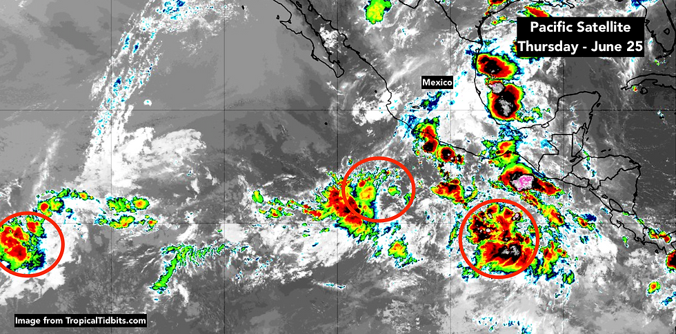
In the Pacific off the coast of Mexico, things are popping. The National Hurricane Center is tracking three distinct systems, which are trying to organize. It is believed that this surge in development is being enhance by a type of wave that travels around the earth in the upper atmosphere – technically called a Kelvin Wave. When one of these passes by, it can be a factor in enhancing or squashing tropical development potential.

These waves can be amorphous and difficult to track, but they move from west to east. There are projections that this wave will be over the Atlantic in a week or two, which might enhance the possibility of something developing. On the other hand, the Saharan Dust will continue to be a negative factor for development.
The bottom line… we’ll see. We don’t try to predict in any detail past 5 to 7 days.

Comments