
The Traditionally Busiest Part of Hurricane Season Begins as Hawaii Watches Yet Another Storm

The great Dr. Bill Gray, who conceived of the idea that tropical activity could be forecast in advance by predicting El Niño, used to ring a bell every August 20 to signal the start of the active part of the hurricane season. And here we are.

This year there is nothing to ring or talk about, of course. Long-range computer forecasts do indicate that a system might develop in the Atlantic next week from a disturbance forecast to move off Africa about Tuesday. It could head in the direction of the northeast Caribbean, but that's a long way off.

WATCHING OUT FOR HAWAII
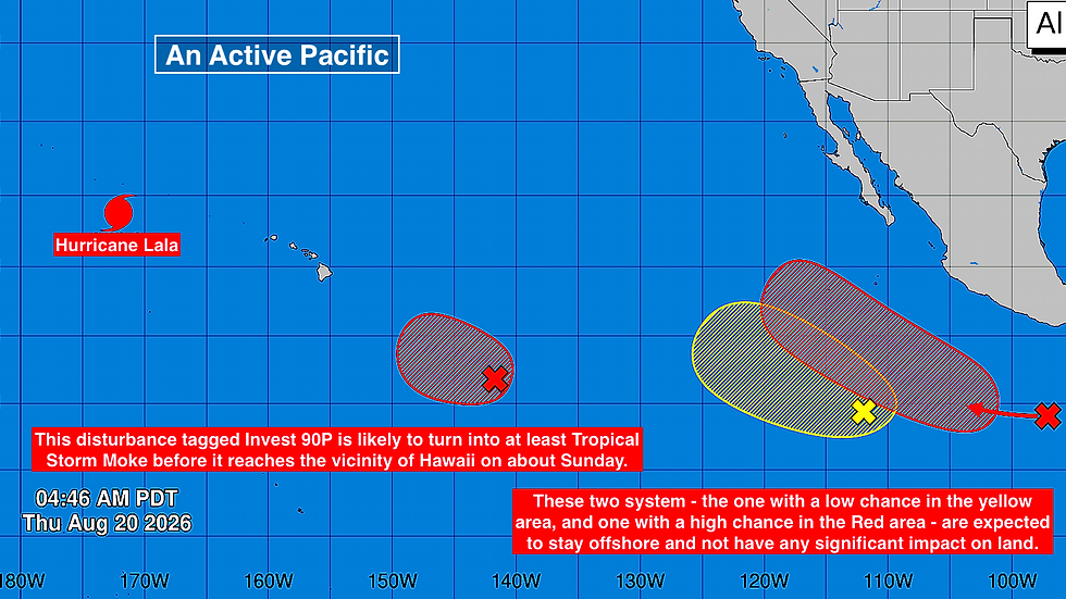
Annoyingly and unbelievably, another Pacific system is heading in the general direction of Hawaii.
The atmospheric environment does not look conducive to rapid strengthening. The odds favor the system moving near or over the Hawaiian Islands as a tropical storm are about 60%, with the chances of it being a hurricane in the 10 to 15% range.

The forecast calls for the center of the storm that will get the Hawaiian name "Moke" to pass south of the islands, but it's not 100%.
On the current schedule, the weather will deteriorate on the Big Island late Saturday Hawaii time with the peak effects occurring Sunday. It should be moving away Monday with some fringe effects on the other Hawaiian Islands.
Everyone in Hawaii should stay well informed. The forecasts are likely to be adjusted as the system develops.
Although forecasts for a just-developing system have intrinsic uncertainty, the best evidence is that the southern half of the Big Island will see most of whatever impact there is on the state.
That part of Hawaii Island has only just begun to try to recover from Hurricane Lala that hit just last week. Roads, bridges, and some 100 homes were washed away by rampant flooding. Over 3 feet of rain fell on the mountain causing mudslides and paths of destruction when it surged downhill.
ELSEWHERE IN THE PACIFIC
Another couple of systems are forecast to develop offshore of Mexico. Computer forecast models predict that the system at the red X will become a hurricane, but all indications are that it will stay offshore. It looks likely to get the name Iselle.
Ironically, Tropical Storm Iselle of 2014 is the strongest tropical system in the modern record book to have made landfall on the Big Island in the same area that was devastated by Hurricane Lala. The center of Lala just missed the Big Island, so it didn't count as a direct landfall. In 2014, Iselle was estimated to have 60 mph winds at landfall, but it had been a hurricane 12 hours before with a large eye. Broad tropical systems do more damage.
Long-range computer forecasts predict that likely-Iselle will move in the general direction of the Hawaiian Islands, but be a relatively weak system by that time. Dry air and cool ocean water should take their toll.
The system that could develop in the yellow area is not expected to be a threat.
And there is another system that is expected to develop behind that.
Comments