
Tropical Disturbance (Invest #97L) in the Caribbean likely to become Tropical Storm Rafael this week
- Bryan Norcross

- Nov 3, 2024
- 3 min read
A cluster of thunderstorms is gathering in the southern Caribbean north of the Colombia coast. The National Hurricane Center has tagged it Invest #97L. It's currently part of a large low-pressure system but is expected to consolidate into an organized tropical depression and eventually Tropical Storm Rafael over the next few days.
By tomorrow, the system should be near Jamaica. The consensus of the various computer forecasts is that it will be a tropical depression by that time. It could become Rafael by the end of the day.

The flow around the strong high-pressure system off the Southeast coast should push the system to the northwest, likely over the west end of Cuba. On the current schedule, the depression or likely-Rafael will move into the Gulf on Wednesday.
The air will be squeezed between the low pressure of the Caribbean system and the high pressure over the Atlantic. The result will be gusty winds and dangerous ocean conditions along the east coast of Florida, especially the southern half of the Florida Peninsula, at least Monday to Wednesday. Strong winds could also affect the Florida Keys and Southwest Florida on Wednesday, depending on the track of likely-Rafael.
Flooding rain is possible over the Caribbean islands west of Puerto Rico. The rich tropical moisture is forecast to spread from south to north over the Florida Peninsula starting Tuesday. Likely-Rafael's moisture is forecast to cover much of the state through Thursday, at least.
There is disagreement among the computer forecast models on how strong likely-Rafael will be when it moves into the Gulf of Mexico. The predictions range from a low-end tropical storm to a Category 1 hurricane. Bear in mind that the system hasn't even developed yet, so we shouldn't focus on any one forecast. The atmospheric environment looks to be reasonably conducive for development, however. So at least a healthy tropical storm is a reasonable possibility.
Once likely-Rafael gets to the Gulf, the steering currents may weaken, meaning the system will move more slowly. Forecasts for slow-moving systems are always extra iffy, and this one hasn't even formed yet.
Reasonable tracks for the end of the week range from west toward Mexico or Texas to north toward the Florida Panhandle. But no matter where it goes, the current best evidence is that it will weaken significantly before it gets to the coast.
Hostile upper-level winds have been screaming across the northern Gulf and the Southeast, and unless the long-range computer forecasts are completely wrong, they will continue. All of the long-range projections weaken the system significantly before it reaches the Gulf Coast.
We have to be ready for a nerve-racking situation if likely-Rafael intensifies into a strong tropical storm or hurricane in the Gulf – even with a forecast of significant weakening before landfall. For now, just stay informed.
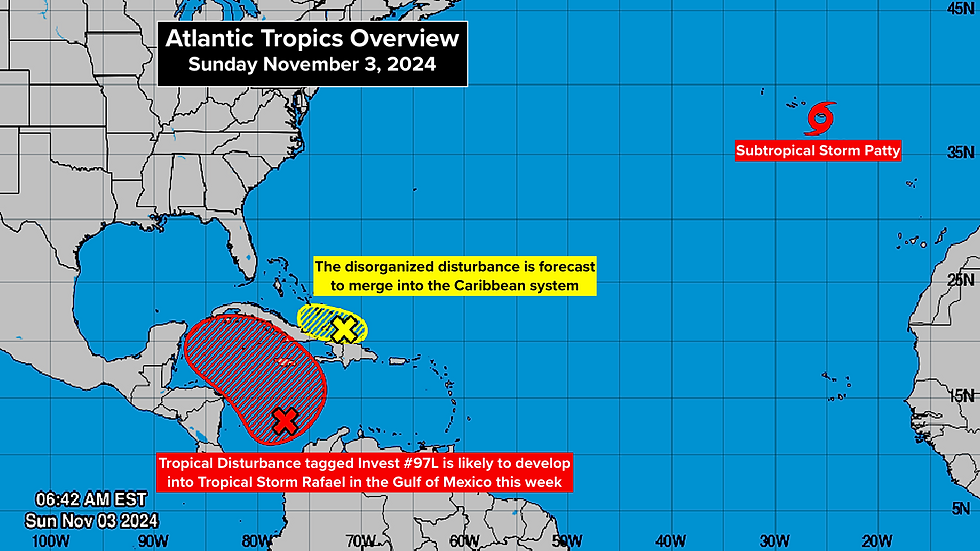
NORTH OF THE CARIBBEAN, the disorganized disturbance passing over the Turks and Caicos Islands and the Southeastern Bahamas is unlikely to amount to anything. Its moisture is forecast to be absorbed by the developing Caribbean system.
IN THE NORTHEAST ATLANTIC, Subtropical Storm Patty is passing over the eastern Azores islands. The storm is in the weakening stage and will likely become non-tropical by tomorrow.

Patty's remnants will head toward Portugal or northwestern Spain, but it will be a weak system by the time it gets there about Tuesday.
Comments