
Tropical Storm Fay Could Briefly Form in the Atlantic and a Busy Week Coming for the Pacific

BUT FIRST… SEPTEMBER 19, 1926
South Florida was reeling. Coastal cities and towns were devastated. Communications systems were down. Beach towns were impassable because the roads were up to 3 feet deep in sand. The water was undrinkable if it ran, and the word went out that septic systems might not work. Food was in short supply.
The only newspaper that published that Sunday was the Miami Daily News, and they could only print one page without electricity.


Reporters were just beginning to understand the magnitude of the disaster. Everywhere they looked, there was damage and death. It was actually worse than they understood in Miami because the footprint of the catastrophe included Hollywood, Dania, Fort Lauderdale, and other points north.
The Great Miami Hurricane of 1926 had crossed the state leaving a horrendous scene of death and destruction in Moore Haven, a small town on the west side of Lake Okeechobee. Now, it was heading toward Pensacola.
IN THE ATLANTIC IN 2026
A small well-developed disturbance southwest of the Azores tagged Invest 99L has a high chance of developing into at least a tropical depression, and it could well become Tropical Storm Fay. If it's going to do it, however, it needs to do it quickly.
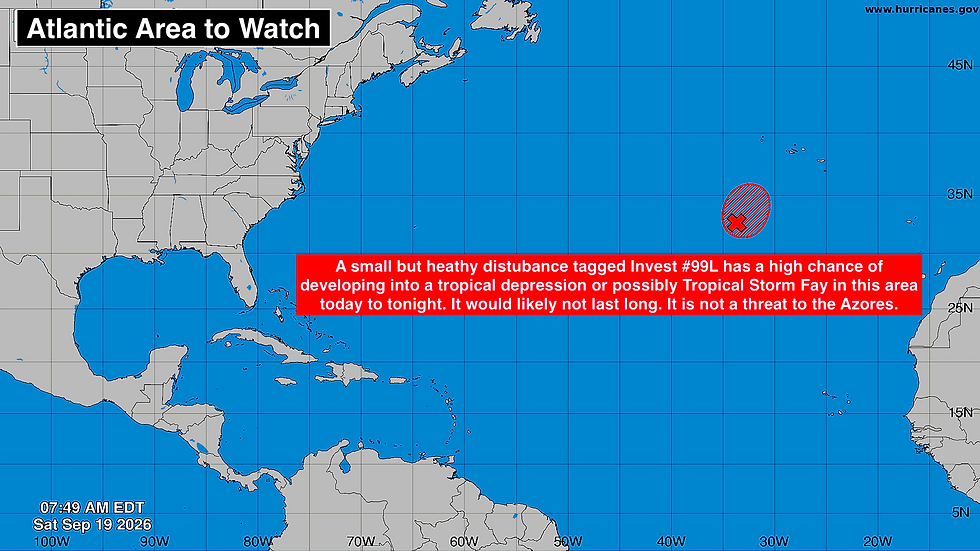
The system has temporarily found a patch of atmosphere conducive to development, but that looks to change by Monday. The consensus of the computer forecasts is that the disturbance, whatever form it takes, will loop to the southwest and die over the open Atlantic.
IN THE PACIFIC
This is going to be an active week.
The disturbance off the Mexican coast has been designated Invest 99E by the National Hurricane Center. Forecasters have the odds in the high category that it will develop into a tropical depression or tropical storm in the next couple of days. The consensus of the various computer forecast models is that the system will reach hurricane strength over the very warm Pacific waters and track close to or over the Mexican coast. Everybody along the central coast of Mexico should stay well informed.

The middle system, which was tagged Invest 98E, is also likely to develop into a tropical storm or hurricane, but it looks likely to remain over the open ocean.
The system that's forecast to track southeast of Hawaii is the remnants of former Tropical Depression 15E. The NHC is giving it a medium chance of regenerating over the next week.
The disturbance is forecast to move very slowly or stall south of Hawaii next week. Exactly how it will play out is unclear, but an extended surge of tropical moisture over some or all of the islands is possible during the second half of the week. Plan to stay informed of the latest alerts from the National Weather Service in Honolulu.
Comments