
Tropical Storm Warnings for the Upper Texas Coast and Southwest Louisiana Could Be Issued Today for #97L

The small disturbance tagged Invest 97L over the Gulf south of New Orleans is showing signs of development. It's trapped under the heat dome high to the north, which is pushing it in the direction of the Upper Texas Coast and southwestern Louisiana.
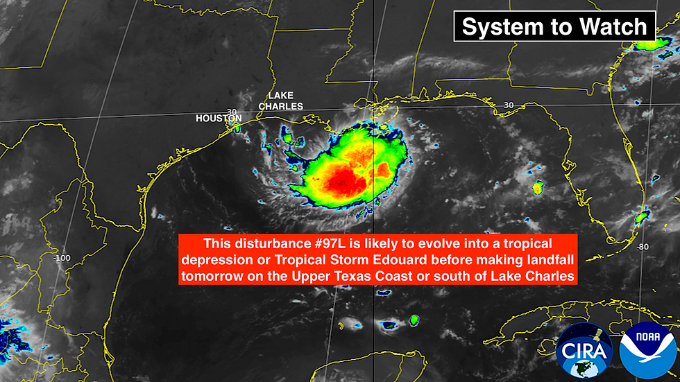
Encouraging it to develop, the Gulf water is very warm, and the curvature of the northwest Gulf coastline might enhance the spin of the system. On the other hand, the upper-level winds have been strong enough to push the thunderstorms to the east side of the circulation and inject dry air into the tiny disturbance.
It looks likely the system will overcome the negative factors and develop into at least a tropical depression. The computer forecasts indicate about a 30-35% chance of it strengthening enough to be designated Tropical Storm Edouard before making landfall – likely in the second half of tomorrow.
The biggest concern is the potential for heavy rain from Metro Houston to southwestern Louisiana south of Lake Charles. Stay aware of any flood alerts issued by the National Weather Service.
If the system does become Edouard, by definition, there will be winds over 40 mph associated with the circulation. They won't cover a large area, but a band of strong winds could impact the coastline east of where the center comes ashore.
Hurricane Hunters will be on station monitoring potential Edouard until landfall. These small Gulf systems can spin up quickly, so they want to be sure there are no big surprises.
REMNANTS OF DOLLY
Periods of heavy rain from ex-Dolly are still a threat over Puerto Rico, the Virgin Islands, and the nearby islands. Even as the system heads in the general direction of Florida over the next few days, the enhanced moisture will trail behind. Watch for flood alerts from the National Weather Service in San Juan.

The atmospheric environment ahead of the system is quite hostile in its path, so no development is expected for the next 2 to 3 days.
Once the remnants reach the vicinity of Florida late in the week, it has a little better chance to develop, but there's probably not going to be much left of the system, so development odds are very low.
Depending on the path of the moisture, it could enhance an already rainy weather pattern over the Florida Peninsula later this week. Most likely the system will smear out into a weak moisture surge.
Elsewhere, there are no threats evident in the Atlantic.
IN THE PACIFIC
Tropical Storm Lowell still needs some watching. The system is forecast to intensify into a hurricane and track well south of the Hawaiian Islands. Around next weekend, however, it is forecast to turn north. If the consensus of the best long-range forecasts are right, it will clear the islands to the west.
There continues to be some uncertainty about exactly when that turn north is going to occur, however.
Once Lowell becomes a hurricane, assuming it does, hopefully the forecasts will become a little more focused, and we can have confidence that the system will swing wide of Hawaii.

Meanwhile, Hurricane Karina has blown up into a powerful storm. It will also track in the general direction of Hawaii, but unlike Lowell, it will be over much cooler water before it gets anywhere in the remote vicinity of the islands.
Current forecasts keep it well to the north as a relatively weak storm, so at this point, there's no concern. Again, however, let's be sure it doesn't misbehave.
Another potential hurricane will develop offshore of Mexico, but it is not expected to be a direct threat to land. There's also a slight chance of another system well southwest of Hawaii, which will head into the open Pacific.
Comments