WATCHING FOR TROPICAL DEVELOPMENT OF THE LARGE DISTURBANCE IN THE EASTERN ATLANTIC
- Bryan Norcross

- Jul 27, 2020
- 3 min read
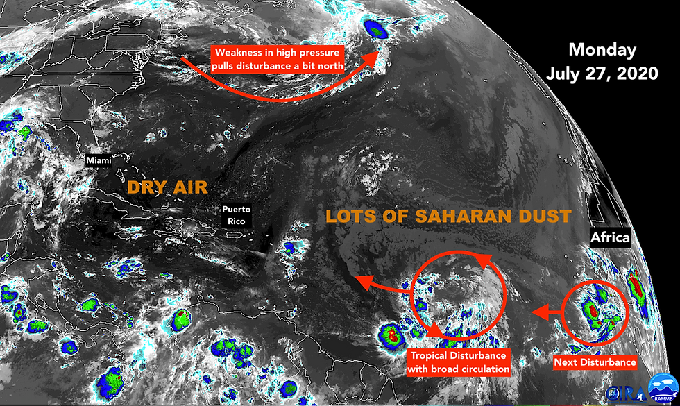
The large tropical disturbance midway between Africa and the Caribbean islands has a broad circulation. It’s trying to become the next tropical depression, and perhaps Tropical Storm Isaias.
There are a number of differences between this system and the previous system that became Tropical Storm Gonzalo. First, this circulation is a lot bigger and contains much more moisture. Tiny Gonzalo did not have the size or the moisture to fight off the layer of Saharan dust that is spread across the Atlantic just north of the deep-tropics track where these disturbances can organize.

The dry air acts like a sponge, sucking moisture out of tropical systems. Without enough moisture, they choke and die. Thankfully Gonzalo was on its way out as it passed through the southern Caribbean islands on Saturday.
If this new one is going to amount to much, it will have to fight off the dust as well, but with a big circulation and enough moisture, it has a shot. All of the computer forecast models predict that it will be able to organize, to at least some degree, over the next couple of days as it heads toward the northeastern Caribbean islands.
Another difference this time is the weather pattern to the north of the disturbance and the plume of dust. A strong high-pressure system has spanned the Atlantic for the last 10 days or so. The flow around that high has driven everything east to west – the disturbances and the dust included. It has also given us a nice ocean breeze in South Florida.
Moving forward, however, a series of low-pressure systems moving across Canada and the North Atlantic will weaken the west end of the high. That weakness will allow the disturbance to slowly lift north as it pushes toward the Caribbean.
The weakness is especially pronounced at the mid-levels of the atmosphere, so as a general statement, the stronger the disturbance, depression, or storm becomes, the harder turn to the north it will make. Stronger systems stand taller in the atmosphere, and so they are steered by winds higher up. Weaker systems tend to be caught in the dominant east-to-west trade-wind flow, and therefore move faster in westerly direction.
This interdependency between the intensity of a system and its future track is the heart of the challenge in predicting where weak or developing systems are going to go. Generally, if you don’t know how strong a system is going to be in a couple of days, you cannot have confidence in where it’s going.
In this case, there is general agreement in the computer forecast models that the disturbance will be near the northeastern Caribbean islands about Wednesday as a tropical depression or low-end tropical storm. At that point forecasts diverge.
Models that predict the storm will stay weak, take it off to the west through the Caribbean, essentially as a moisture surge. Models that predict it will strengthen, generally take it north of the islands in some fashion.
In any case, there is a lot of dry, dusty air across the Atlantic. Even if the disturbance fights off the dry air enough to develop, it will have to keep doing that for a good part of its life. This adds another layer of uncertainty onto the intensity forecast, but the odds are, the dust will keep the system from getting terribly strong over the next few days.
The point is, until we see how and exactly where the disturbance develops, and if it can insulate its circulation from the dry air, it’s too early to have confidence in any of the forecasts. Stay informed.
Elsewhere, the remnants of Hurricane Hanna are dying out over northern Mexico, but they left behind a lot of moisture over flooded or saturated ground. As a result, the flood threat remains over northeastern Mexico and Deep South Texas.
Hurricane Douglas jogged to the north just enough that the worst of the storm missed Oahu, the population center of Hawaii. Its track is also just far enough north of Kauai, so the feared direct hit turned into a close miss.
Back in the Atlantic, another large disturbance has moved off of Africa, but the early prediction is that the Saharan Dust will give it a tough time, at least for now.

Comments