
Development odds increase for the disturbance in the central tropical Atlantic
- Bryan Norcross

- Sep 13, 2022
- 2 min read
Tropical Disturbance #1 is showing some signs of organization as it tracks through the tropical Atlantic heading in the direction of the northeastern Caribbean islands. On the current schedule, it will impact the islands from late Thursday through Friday.
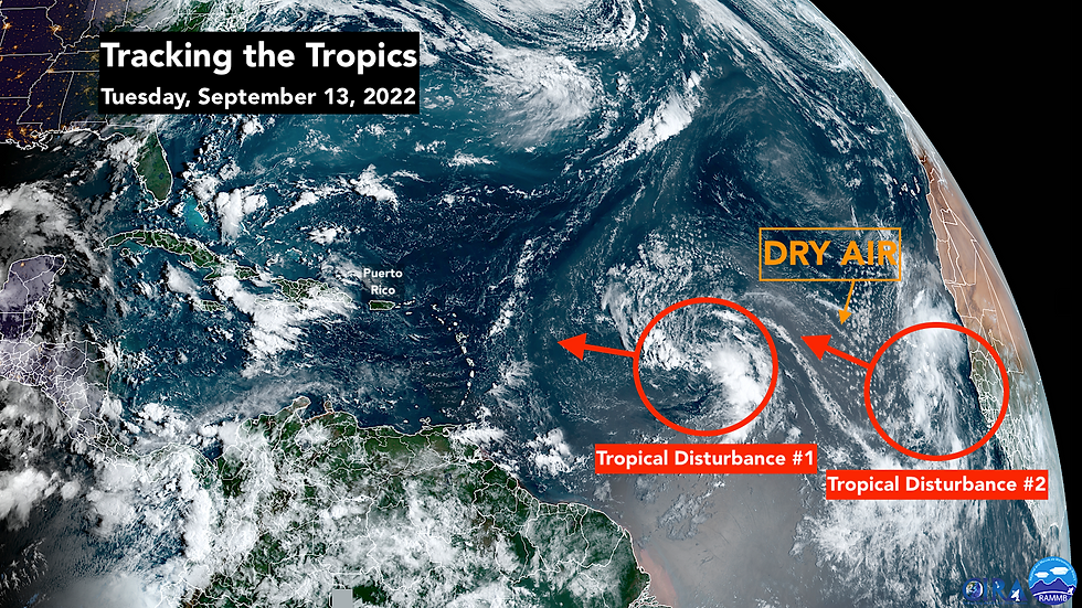
This disturbance has a large envelope of moisture surrounding it, which might help it hold off the dry air that covers much of the eastern Atlantic. And it has a marginally conducive environment for organizing and strengthening, at least for now.
The National Hurricane Center has increased the disturbance’s odds of development into at least a tropical depression to medium over the next 5 days. The development area drawn in orange indicates that it’s not certain how far along the disturbance might be in that area when it develops, if it does.

Hostile upper-level winds will be near the disturbance on its trip to the islands, so the question will be whether the system finds a pocket where the surrounding environment is conducive enough to develop. The upper winds can force nearby dry air into the disturbance gumming up the works, so we’ll watch how the weather pattern develops.
Regardless of development, Tropical Disturbance #1 will likely bring heavy rain and gusty winds to Puerto Rico and the surrounding islands at the end of the week. The ground on the islands is saturated from frequent heavy rains lately, which will increase the chance of mudslides and local flooding if too much rain comes at once.
Everybody in the northern Caribbean islands should stay informed.
Looking farther ahead, the disturbance in some form would be in the vicinity of Florida or the Bahamas around the middle of next week. It’s too soon to speculate on the track or organization level of the system at that time. Forecasts for poorly developed systems are always subject to large errors and often change day by day.
Tropical Disturbance #2 is over the Cabo Verde Islands off the coast of Africa. This disturbance has a slight chance of developing as it moves to the west. The evidence, however, is that it will succumb to dry air and hostile winds over the next few days.
Behind this system is another disturbance over Africa, which will cross into the Atlantic tomorrow. This one will be farther south, so the odds of it turning north into the central Atlantic are lower. It will be a system to watch.
Right now, our attention is on Tropical Disturbance #1. Let’s see what happens over the next few days.
Comments