Ida is strengthening as Louisiana braces for a hurricane hit on Sunday
- Bryan Norcross

- Aug 27, 2021
- 3 min read
Once again, Louisiana is the bullseye. Tropical Storm Ida is likely to become a strong hurricane as it makes a beeline for the Gulf coast south or southwest of New Orleans. While Mississippi and the rest of the Louisiana coast are in the threat zone, the steering pattern is very well established so the odds of this storm directly impacting the Greater New Orleans and Baton Rouge areas are pretty high.

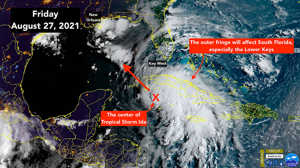
Ida will track over the western end of Cuba tonight. It will be moving right along, so the interaction with the land is not expected to knock it down much.
The outer fringes of Ida will be close to or over the Lower Keys. Fast moving squalls with very gusty winds, which will be dangerous for boaters, are forecast to rotate through the Keys tonight and Saturday. Ida may pull some gusty downpours across all of South Florida over the weekend, but the strongest squalls should be in the Lower Keys closer to the storm.
When Ida gets into the central Gulf on Saturday, it will have lots of fuel to work with. Very warm water flows north between Mexico and Cuba. Most of it hangs a right and flows south of the Keys and then up the Florida southeast coast as the Gulf Stream. But some of it breaks off and creates a deep pool of warm water in the Gulf called the loop current. Unfortunately, Ida is forecast to pass directly over this hot patch with the highest-octane hurricane fuel anywhere in the Gulf.
The upper-level winds are forecast to be conducive for steady, perhaps rapid, strengthening. The unknown is whether the structure of the storm will come together to take advantage of the conditions over the Gulf, and how soon.
The National Hurricane Center is forecasting Category 3 strength at landfall, so people really should plan for a Cat 4. It’s a daunting situation.
If Ida takes a track something like the National Hurricane Center is forecasting, it will mean big problems for southeast Louisiana and be scary for metro New Orleans. It's a complex area – much of it below sea level – with multiple levees and flood-protection structures defending towns and cities.
The immediate New Orleans area is surrounded by a massive flood wall and levee system. It is not designed to stop the storm surge from every hurricane. But it will not fail, like the flood walls did in Hurricane Katrina. If the surge level were to overtop the system, the water would stop flowing as soon as the water level outside the barriers dropped. In Katrina it toppled the flood walls, so the water kept coming.
The New Orleans system is advertised be tall enough to fully defend against a “fast-moving Category 3” hurricane. This would appear to fit that description, and the storm might track far enough west to avoid fully taxing the flood defenses. But it’s a close call.
Outside the “Greater New Orleans Hurricane and Storm Damage Risk Reduction System” – the official name of the post-Katrina levees, flood walls, and gates – there are other communities protected by less robust levees. It’s a very complex patchwork or waterways, barriers, and residential and commercial areas. It is going to be a daunting challenge for officials there to keep people safe by being sure they are riding out the storm on high ground.
Water is slowly rising on the east-facing coastline outside of New Orleans. It will continue to rise on the east- and south-facing coasts of Louisiana and the coast of Mississippi, Alabama, and the Florida Panhandle until the Ida is well inland late Sunday.
The National Hurricane Center is forecasting 7 to 11 feet of water above normal high tide in the most vulnerable areas. Significant storm surge is possible all the way east to the Alabama/Florida line.
This is a very dangerous situation. Since we can’t precisely forecast the intensity, and the intensity is a big component of the storm surge, preparations have to be made for a stronger storm than the explicit forecast.
Today and tomorrow are preparation days. That’s it.

Out in the Atlantic, Tropical Disturbance #2 still might develop into a least a tropical depression. And it now looks like Tropical Disturbance #3 has a decent chance of becoming a tropical storm. Both systems will stay in the middle of the Atlantic well away from land.

The long-range computer models are hinting at a strong system coming off Africa early in the week, and something that might follow Ida out of the western Caribbean late in the week. Nothing is forming yet. It’s just something to keep an eye on.

Comments