
Powerful Hurricane Sam heads north while we watch two more disturbances in the tropical Atlantic
- Bryan Norcross

- Sep 27, 2021
- 2 min read
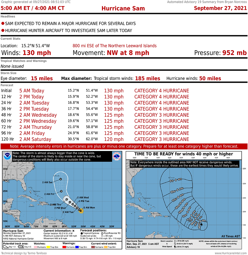
Hurricane geeks have been awed by Hurricane Sam’s display of raw power over the past couple of days. It found an internal balance that allowed it to maintain its structure and intensity at a very high level. Usually, strong hurricanes go through cycles of weakening, expanding, and restrengthening, but sometimes they find a structure and atmospheric pattern that keeps them running on all cylinders for longer. We’re finally seeing slight weakening, but Sam is still a very powerful hurricane.

Thankfully, Sam is turning north more than 600 miles east of the Caribbean islands. In addition, it’s a small diameter storm, so the bad weather is well offshore.
Sam is forecast to stay strong, but its wind speed has likely peaked as factors that would tend to weaken it come into play. For one thing, an internal weakening and expanding cycle has apparently just completed. Also, it’s moving so slowly that it might churn up cooler ocean water under the circulation depriving itself of heat.
Sam has open ocean ahead of it until the end of the week. It might impact Bermuda, but it’s a small island in a big ocean. They will have to be unlucky to get hit head-on by a small hurricane, but it certainly can’t be ruled out. Sam should still be quite strong when it gets to that latitude.
Sam will stay far away from Florida and the East Coast of the U.S.
On the other side of the Atlantic, twin disturbances are likely to develop in the next few days. There’s a good chance Disturbance #1 will consolidate out of a broad disturbance well off the African coast. Early indications are that it will crawl west in the general direction of the Caribbean islands – another slow-moving storm.
Atmospheric conditions look conducive for Disturbance #1 to organize into at least a tropical depression, but long-range forecasts show a pretty hostile environment as it approaches the islands. As always, we shouldn’t pay too much attention to forecasts for systems that haven’t yet developed.

Disturbance #2 is right at the African coast. It appears the atmospheric environment will be conducive for this system to develop in the next few days, as well. Its early forecast takes it on a more northerly track.
Nothing is going to happen quickly with either of these systems.
The remnants of Tropical Storm Peter have a couple-day window to redevelop into a tropical system. In any case, it’s heading into the North Atlantic.
Nothing else looks imminent, but the way things are spinning up this year, you never know.
Comments